About DLD
The District Level Database (DLD) for Indian agriculture and allied sectors provides a comprehensive one-stop shop for data on rural sector that enables testing of key research hypotheses, identification of relevant districts / regions for technology dissemination, promoting rural pro-poor programs / development initiatives and identification of relevant representative districts for micro level assessment.
It acts as a link between country-level macro data and household-level micro data. The consistent recording and detail at district level makes it a powerful research response tool for priority setting and in tracking inter-district and intra-district economic changes.
Structure of the database
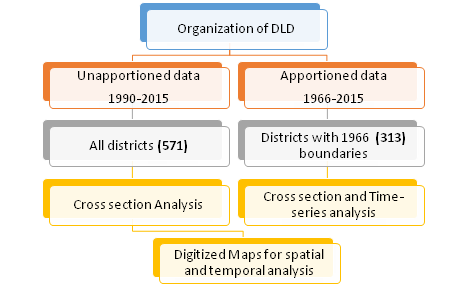
The districts in each state of the country have been divided from time to time based on political, socio-economic, linguistic and other factors. There were 313 districts in the 16 states in 1966 (excluding northeastern states (except Assam) and Jammu and Kashmir).
By 2015 four new states were created from the 16 states to make it 20 states and the number of districts in the 20 states increased to 571. To ensure continuity in the database for time series analysis and for spatial and temporal analysis using GIS maps, a methodology was devised for apportioning the data of the newly formed districts back to its parent district, i.e., 1966 district boundaries.
Thus, the database is divided into two datasets: Apportioned database with 1966 district boundaries and unapportioned database with current district boundaries (in our case upto 2015-16). The apportioned database includes data from 1966 to 2015-16 while the unapportioned database spans 1990 to 2015-16.
The data on environment variables (AET, PET, PPT, etc) is available only for unapportioned data from 1956 to 2015. Besides the two data sets, another set of variables are included under ‘Additional data’, and includes data files on season wise crop area and production, break up of fruits and vegetables area and production by crop, night lights, agricultural credit etc. These data are unapportioned and the years covered are for recent years and are also not uniform across data files.
Notes:
1. Unapportioned data: Includes data for all districts as on 2015-16
2. Apportioned data: Includes data for 1966 base district boundaries only i.e., data for all districts formed after 1966 is given back to their parent district/ districts and removed from the file.
Database development and partners
The current update of the district level database from 2010 onwards is being carried out under an ICRISAT–TCI (Tata Cornell Institute of Agriculture and Nutrition) joint collaborative project on “Updating the meso-level database for India and developing an interactive tool for public access and use”. A unique feature of this update besides data generation and maintenance is the development of an interactive user friendly web tool for easy data access, retrieval, and storage of the data. Visualization of graphs and spatial maps will be an additional feature of the web tool.
Historically since 1980 the district level database is being maintained by ICRISAT with data going back to 1966 with funding support under various bilateral projects and supported by several donor agencies and intuitions. For example, the World Bank, System-wide Livestock Program (SLP-CGIAR), BMGF (Bill and Melinda Gates Foundation) in collaboration with the National Institute of Agricultural Economics and Policy Research (NIAP) a think tank of the Indian Council of Agricultural Research (ICAR), New Delhi. A number of research papers/articles have been published using this database by lead research institute in India and elsewhere.


Acknowledgement
This work was undertaken as part of the CGIAR Research Programs on Grain Legumes and Dryland Crereals (GLDC) led by ICRISAT and Policies, Institutions, and Markets (PIM) led by the International Food Policy Research Institute (IFPRI). Funding support for this web tool was provided by Tata -Cornell Institute (TCI) and CGIAR Research Program on Grain legumes and Dryland cereals (GLDC).
This web tool has not gone through IFPRI’s standard peer-review procedure. The data avaliable here has been collated from different sources by ICRISAT. While great effort was taken to obtain high-quality data, the accuracy or reliability of the data is not guaranteed or warranted in any way. The data are provided ‘as is’ and in no event shall ICRISAT, GLDC, PIM, TCI and CGIAR doesn’t bear responsibility for any nonconformities, defects and errors in the data and be liable for any damages resulting from use of the data.
Team

S Nedumaran
Senior Scientist (Economics)ICRISAT

P Parthasarathy Rao
Expert ConsultantICRISAT

R Padmaja
Senior scientist (Sociology)ICRISAT

Murali Krishna Gumma
Senior Scientist (Remote Sensing)ICRISAT

Irshad Ahmed
Manager, GISICRISAT

Abhishek Rathore
Principle scientist (Statistics and Data management)ICRISAT
Satish Nagaraji
Senior Manager, Digital Agriculture (M&E and Tools)ICRISAT

P Jyosthnaa
Senior Scientific officerICRISAT

E Jagadeesh
ConsultantICRISAT

Chaitanya Sarma
ProgrammerICRISAT
Mathew Abraham
Asst. DirectorTata Cornell Institute of Nutrition and Agriculture (TCI)

Andaleeb Rahman
Post Doctoral AssociateTata Cornell Institute of Nutrition and Agriculture (TCI)

Kiera Crowley
Research Support SpecialistTata Cornell Institute of Nutrition and Agriculture (TCI)

Arun Kiran
ConsultantICRISAT
Disclaimer and terms
Several data sources were utilized to compile the database. A common source for some of the key variables is from the Directorate of Economics and Statistics, Ministry of Agriculture and Farmers Welfare, Government of India.
Additionally, for several variables and for the latest available years, staff working on this project had to visit offices of the State Directorates of Agriculture, State Bureaus of Economics and Statistics, Department of Animal husbandry, Horticulture, etc.
Details on the sources for each state are given in the section on ‘data sources’ in the data documentation manual. The support and cooperation extended by the state departments visited are highly appreciated, and we take this opportunity to thank them for enabling the update. But for their cooperation, this database would not have been compiled.
Disclaimer for Data
These data and documents are licensed under a Creative Commons Attribution 4.0 International license. You are free to copy, distribute and transmit the data as long as you acknowledge the ICRISAT through DOI provided in this page. While utmost care has been taken by ICRISAT and data authors while collecting and compiling the data, the data is however offered "as it is" with no express or implied warranty. In no event shall the data authors, ICRISAT, or relevant funding agencies will be liable for any actual, incidental or consequential damages arising from use of the data. By using this data source, the user expressly acknowledges that the Data may contain some nonconformities, defects, or errors. No warranty is given that the data will meet the user's needs or expectations or that all nonconformities, defects, or errors can or will be corrected. The user should always verify actual data. Therefore, the user bears all responsibility in determining whether the data is fit for the user’s intended use. The user of the data should use the related publications (if any) as a baseline for their analysis whenever possible. Doing so will be an added safeguard against misinterpretation of the data.
Disclaimer for Map
The opinions in this publication are those of the authors and not necessarily those of ICRISAT or National Remote Sensing Agency (NRSA) or UK Department for International Development (DFID). The designations employed and the presentation of the material in this publication do not imply the expression of any opinion whatsoever on the part of ICRISAT or NRSA or DFID concerning the legal status of any country, territory, city, or area, or of its authorities, or concerning the delimitation of its frontiers or boundaries. The maps are not intended to predicate political boundaries, and the publishers hold no responsibility whatsoever in this regard. Where trade names are used this does not constitute endorsement of or discrimination against any product by ICRISAT or NRSA or DFID.